🚀 Amigos de los mapas y los datos, os comparto una recopilación que he preparado para ayudaros en vuestros proyectos. Además, Open Source!!
🌎 Las mejores 25 herramientas de mapas Open Source
Pero además, os quiero contar un poco sobre mapas y datos. Sobre todo, de cierta confusión que hay con muchos
Leer más...
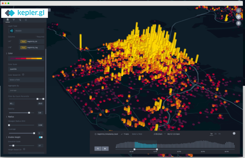
Kepler.gl [https://kepler.gl/] es una herramienta web de código abierto
desarrollada por Mapbox y Uber orientada a la visualización y análisis de datos
espaciales sobre mapas interactivos.
La herramienta permite construir fácilmente visualizaciones de datos sobre mapas
interactivos que pueden ser integrados en plataformas de terceros como CARTO,
Leer más...
One more time, good news from one of our favourite partners: Carto
[https://carto.com/]
You can see an example of the power of Location Intelligence (joining geomaps
with Business Intelligence in this near real-time Dashboard with traffic
information of Madrid City
[http://pentaho.stratebi.com/pentaho/api/repos/%3Apublic%
Leer más...
It is a Fantasy Map Generator
[https://bl.ocks.org/Azgaar/b845ce22ea68090d43a4ecfb914f51bd]based on D3 Voronoi
diagram rendered to scalable svg.
Use randomto genarate the map with default options, customizeto make your own
shape.
Project goal is to create a procedural generated map for my Medieval Dinastygame
simulator. So a
Leer más...
The web-based iD editor is designed to help create an even better, more current
OpenStreetMap by lowering the threshold of entry to mapping with a
straightforward, in-browser editing experience.
Head over to OpenStreetMap and start editing today
[https://www.mapbox.com/blog/get-on-the-map/]! You can make meaningful
contributions with just
Leer más...
This year, OSGeo and FOSSGIS e.V. as organizer invite you to Bonn, Germany
between August 20th and 28th to share and acquire knowledge, acquaintances,
friends and positive energy through all the activities we are planning for you:
code sprints, workshops, B2B meetings, pub race, icebreaker, gala event and, of
Leer más...
This workshop uses a data bundle
[http://files.boundlessgeo.com/workshopmaterials/postgis-workshop-201401.zip].
Download it and extract to a convenient location. This workshop uses OpenGeo
Suite [http://boundlessgeo.com/solutions/opengeo-suite/download/]. Download it
and place it in a convenient locatio n
Workshop Modules
[http://workshops.boundlessgeo.com/postgis-intro/#workshop-modules]
Leer más...
[http://medialab-prado.es/mmedia/14462/view]
Os mostramos el septimo video (ver primer video: Presente y futuro del Business
Analytics [https://todobi.com/video-open-analytics-1-business/], el segundo:
Analizando con R [https://todobi.com/video-open-analytics-2014-2-analizando/], el
tercero: Big Data y UX [https://todobi.com/video-open-analytics-2014-3-big-data-ux/],
el cuarto sobre Pentaho [https://todobi.com/
Leer más...
Gran seleccion del Washington Post
[http://www.washingtonpost.com/blogs/worldviews/wp/2013/08/12/40-maps-that-explain-the-world/]
sobre a utilidad de los mapas a la hora representar datos y poder entender la
información
Ver los 40 mapas
[http://www.washingtonpost.com/blogs/worldviews/wp/2013/08/12/40-maps-that-explain-the-world/]
En los Cuadros
Leer más...